


Servicios Personalizados
Articulo
 Articulo en PDF
 Articulo en XML
 Referencias del artículo

 Enviar articulo por email
Indicadores
Links relacionados
 Citado por SciELO
 Similares en SciELO
Bookmark
Revista Científica de Investigación INFO-INIAF
versión impresa ISSN 2308-250X
Info INIAF v.1 n.4 La Paz 2014
ARTÍCULOS
A long-term systematic monitoring framework for on-farm conserved potato landrace diversity
S. de Haan1, S. Polreich1, F. Rodriguez1, H. Juarez1, R. Plasencia1, R. Canto2, C. Alvarez3, A. Otondo4, H. Sainz5, C. Venegas6 and J. Kalazich7
1International Potato Center (CIP), Avenida La Molina 1895, Apartado 1895, Lima 12, Peru.
2 Grupo Yanapai, Jirón Arequipa 421, Huancayo, Peru.
3Centro Andino de Educación y Promociona (CADEP), Jirón Atahualpa 482, Tahuantinsuyo, Cusco, Peru.
4Instituto Nacional de Innovación Agropecuaria y Forestal (INIAF), Calle Batallón Colorados 24, La Paz, Bolivia.
5 Universidad Pública de El Alto (UPEA), Av. Surce esq. Pascoe, El Alto, La Paz, Bolivia.
6Centro de Educación y Tecnología (CET), Chonchi Rural, Sector Notuco, Casilla 40 Chiloé, Chile.
7Instituto de Investigaciones Agropecuarias (INIA), Carretera Panamericana Sur K. 8 Norte, Osorno, Chile.
Introduction
Global environmental change has stimulated different scientific communities to develop frameworks for the systematic monitoring of the conservation status of ecosystems, habitats or specific species ranging all the way from coral reefs, tropical glaciers to endangered flora. Examples of such monitoring initiatives include the Global Observation Research Initiative in Alpine Environments (GLORIA), NOAAs Integrated Coral Observing Network (ICON), World Glacier Monitoring Survive (WGMS), IUCN Red List of Threatened Species, among many others.
The crop genetic resources conservation community has since long expressed concerns about landrace loss and genetic erosion (FAO, 2010; Hawkes, 1983; Ochoa, 1975). Yet, hard evidence of loss of alleles, landraces or shifts in their frequencies is commonly lacking as a consequence of the non-existence of baseline or time series data, fixed monitoring sites, standardized methods, solid partnerships, among other prerequisites needed for systematic monitoring of the conservation status of crop genetic diversity in centers of origin.
There are several challenges for the advancement of in-situ conservation science. One of them relates to the need to develop standard procedures and metrics to measure temporal changes in the conservation status of landraces and wild relatives. Examples of crop genetic in-situ monitoring, particularly of cultivated landraces, are rare. Some exceptions exist (Salick, 2012), but these are generally non-systematic in the sense that they do not cover multiple benchmark sites or countries within the center of origin of a particular crop species, apply standard procedures that are concerted and easily accessible or replicable across species, and foresee regular time intervals with local partnerships for sustained monitoring.
Systematic monitoring is only possible if standard procedures for baseline research, time series and spatial comparisons are developed and agreed upon by different stakeholders. Since the start-up of CGIAR Research Program on Roots Tubers and Bananas (CRP-RTB), the International Potato Center (CIP) has gradually advanced the implementation of a hotspot-based in-situ network for potato landraces in the crop's center of origin. This process started in 2012 and the network is called the Chirapaq Ñan Initiative (Rainbow Route in the Quechua language).The development and implementation a systematic monitoring approach has involved the following components: (i) hotspot identification, followed by standard procedures to measure (ii) total diversity, (iii) relative diversity, (iv) spatial diversity, and (v) collective knowledge. Outputs include different information systems about the landrace conservation status. Networking and attention to country interests, farmer participation and benefit sharing are essential elements of the framework.
Methodology
Hotspot identification
The term hotspot is frequently used in agrobiodiversity science, but may refer to different levels of resolution ranging from country to plot level (Galluzi, 2010; Zimmerer, 2013, 2014) and species to landrace level (Das et al., 2013; Meilleur and Hodgkin, 2004). Here hotspots refer to geographies with a high concentration of distinct landraces. Hotspots serve as representative sites to systematically monitor the conservation status at the intraspecific level, in this case of potato landraces.
Different complementary criteria and methods were used to indentify hotspots of contemporary potato landrace diversity. Criteria included: (i) biogeography of cultivated species and cultivar groups, specifically Solanum tuberosum (Andigenum, Chilotanum, Phujera, Goniocalyx and Stenotomum cultivar groups), S. ajanhuiri, S. curtilobum and S. juzepczukii (Hawkes, 1990; Ovchinnikova, 2011), (ii) expert opinion and consensus (n = 410 experts), (iii) ethnicity and linguistic diversity (Adelaar, 2007; Steward, 1946), (iv) distribution and presence of wild relatives from the primary genepool (S. acaule, S. berthaultii,S. brevicaule, S. candolleanum, S. okadae, S. infundibuliforme, and S. vernei) (v) perceived threat level to conservation, (vi) partnership strength and interest (Horton et al. 2009).
Geographical Information Systems (GIS) spatial overlays were used to map the landrace diversity hotspots. Frequencies of consensus were used to give higher weight to hotspots that were highlighted by several experts. As a result, the following hotpots were identified for different countries: Argentina (Jujuy province), Bolivia (department of La Paz), Chile (Chiloe province), Colombia (department of Nariño, Cauca province), Ecuador (Chimborazo province), and Peru (departments of Cusco, Apurimac, Huancavelica and Huánuco). Within each department or province specific benchmark sites were identified at the district and community level. The surface area of the specific hotspots identified varies from 225 to 1,200 km2.
Baseline research
Detailed baseline research is conducted at the hotspot level involving multiple dimensions. This process started under the umbrella of the Chirapaq Ñan Initiative and has initially involved two hotspots in Peru followed by an additional hotspot in Bolivia. In-depth baseline research takes 36 to 48 months and will result in an open access databases that make the information available to a wide public and includes catalogues, red lists and maps.
Total diversity
A detailed inventory is made of all landraces present in the hotspot as to document total landrace diversity. During three to four consecutive seasons on-farm trials are installed with individual custodian farmers and farmer groups. Standard procedures are followed for: (i) seed tubers separation, (ii) installment of characterization trials, (iii) morphological characterization (Gómez, 2000), (iv) DNA fingerprinting (Ghislain et al., 2009), (v) plant photography and (vi) flow cytometry to determine ploidy, (vii) data management and storage. Main variables include total landrace and allele diversity, but additional (comparative) variables that can be determined include heterozygosity, allele frequency, population differentiation, among other complementary variables (vernacular nomenclature, cultivar group distribution, etc.). The main output involves an (online) hotspot-based catalogue with detailed information about each individual landrace present in the hotspot (see: CIP, 2006; Monteros et al., 2010; Scurrah et al., 2013).
Relative diversity
A quantitative assessment is made of the relative abundance of landraces. Standard procedures involve field sampling of all potato fields grown by a randomly selected sample of households living within the communities covering the hotspot (n= 150-200 households). A minimum of 200 random tuber samples per field are collected and the identity of each sample is determined to the landrace level using vernacular nomenclature. Based on local expert knowledge, involving elder farmers (especially women) and experienced agronomist from the region, a master list of landraces names, synonyms and homonyms is established. A database is established and the following indicators are calculated: (i) overall cultivar frequency (OCF), (ii) relative cultivar frequency (RCF). The OCF is a measure of evenness based on the number of households conserving a specific landrace while the RCF is a measure of relative abundance based on extensive field sampling (Table 1).

The final output is a red list of the conservation status of landraces. Such red lists do exist at the species level for flora and fauna and for crop wild relatives (Butchart et al., 2004; IUCN, 2012; MMAyA, 2009). Furthermore, a qualitative approach exists for landraces (Padulosi and Dulloo, 2012). However, the Chirapaq Ñan Initiative is the first landrace-level monitoring platform to apply a robust quantitative approach. The red list offers a snapshot of the conservation status of all the individual landraces present in a pre-defined hotspot at a given moment in time.
Spatial diversity
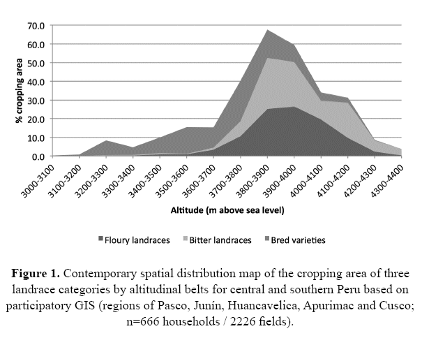
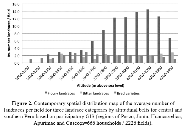
Beyond genetic and species diversity, the landscape-level spatial distribution of landraces is important to monitor. Potato landraces in Andes are concentrated in a tight altitudinal belt at the upper altitudinal limits of where agriculture is possible (De Haan and Juarez, 2010). Standard procedures basically involve participatory GIS with exactly the same households (n= 15-200) involved in the field level sampling described in the previous paragraph (Juarez et al., 2011). GPS coordinates of each field are taken (corners, center) and linked with other key variables for the same unit, such as property regime (communal, private usufruct), cultivar category (floury landraces, bitter landraces or bred varieties), total number of landraces, among other relevant data (tillage system, previous crops grown, etc.).
Involvement of local authorities and youth is essential and will allow for detailed mapping in social contexts that may otherwise be opposed to defining field boundaries. The geospatial database allows for calculation of a range of baseline indicators per individual landrace or for each of three cultivar categories, including: altitudinal distribution and plasticity (min., max. av. in meters above sea level), total and field-size area (m2), concentration (number of landraces by altitudinal belt), etc. (Figures 1 and 2). Outputs include distribution maps of landrace diversity. These maps are shared with community authorities and may include additional layer of information that are useful for land use planning.
Collective knowledge
The collective knowledge that is intrinsically linked to landraces constitutes a unique property. It exists while landraces are in the hand of the farmers who manage and maintain them. Collective knowledge may include folk taxonomy and nomenclature, farmer cuisine, management practices, medicinal use, rituals or cultural expressions, and importantly mechanisms of practice-based intergenerational transfer of know-how. Collective knowledge is dynamic and its monitoring as a non-biological property poses a serious challenge. Collective knowledge many not always be strictly collective and indeed also refer to specialized practices that are only known by few.
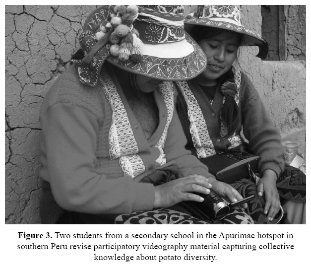
Partners of the Chirapaq Ñan Initiative decided early on that databases were not the best platform for baseline documentation of collective knowledge. It was decided that baseline documentation should be based on youth engagement, intergenerational dialogue and the involvement schools as to develop adapted formal curricula based on local knowledge (Figure 3).Traditionally formal education in the Andes has ignored the local languages (Quechua and Aymara) and culture (Regalsky and Laurie, 2007; Stobart and Howard, 2002), but during the last decade implementation of adapted intercultural bilingual education has increased in Bolivia, Ecuador and Peru (Hornberger, 2000). The main method employed involved teachers and students applying participatory action research, including videography, drawings, open interviews and sound recordings (Nazarea, 2006). The raw content was then used by teachers and specialists in education to develop a multimedia output titled "las papitas de mi comunidad (the potatoes from my community). This education tool offers a partial baseline of localized potato knowledge for three hotspots. The aim is to expand the pilot and thereby the documentation of collective knowledge of landrace diversity. Baseline indicators are of a qualitative nature and include: type of knowledge, number of practices documented, attributes by landrace, among others.
Threats to conservation
Given that landraces are managed by smallholder farmers it is important to understand local perceptions about future conservation, including incentives, disincentives and threats. A baseline of drivers underlying change dynamics, either loss or enrichment, is as important as a baseline of the actual crop genetic diversity itself. Till date the Chirapaq Ñan Initiative has not yet engaged in baseline documentation of incentives, disincentives or threats. Climate stations have been installed in all hotspots. However, besides climate change (Perez et al., 2010; Vuille et al., 2003) there may be many other factors that can potentially affect the fate of on-farm conserved landraces, including migration (Rudel and Richards, 1990), mining (Bury, 2004), pest and diseases (Giraldo et al., 2010; Kroschel et al., 2013) among other. As yet, no standard procedures have been developed for baseline documentation of threats. However, this will be a key priority for future research at each hotspot.
A network approach
Institutional partnerships
Solid partnerships and local leadership at the hotspot level are essential for the success of long-term and systematic monitoring of landrace diversity. An international center such as CIP can facilitate coordination, communication and the use of standard procedures among actors and hotspots. However, the grassroots monitoring work and field-level coordination at specific hotspots has to be led to national and local institutions.
The Chirapaq Ñan Initiative has adopted a consortium approach to monitoring. This implies that several institutions with complementary interest and expertise are stimulated to join forces at the hotspot level. A typical consortium can include a national agricultural research institute, NGO, university and municipalities. At the hotspot level the consortium isled by one organization. However, ideally each member of the consortium should fulfill a complementary role for the action research to be effective.
Farmers alliances and participation
Farmers, both women and men, are the primary actors realizing in-situ conservation through the active management of landraces from planting, harvesting, storage and sales to processing. Basically, conservation is the outcome of diverse utility rationales. Yet, a characteristic of monitoring is that it is passive and potentially extractive and does not necessarily provide direct utility to a farmer. Therefore monitoring should ideally be accompanied by processes that respond to local needs and demands that do not directly influence landrace diversity as such but rather improve farm management, family health and nutrition and or smallholder organization. In practice demands raised by farmers and communities participating in the Chirapaq Ñan Initiative have ranged from capacity building in pest and disease control, exchange of knowledge during field days and support for self-organization. Also a pilot experience linking corporate social responsibility with benefit sharing has been initiated. Specifically, funds made available by a breeding company are used by a recently established association of custodian farmers to support cultivation of landraces, family health and/or schooling of children.
Information management
It is important that baselines are published during the research process or at the latest once the documentation process is completed.
Baseline data should be openly accessible and include clear information about the procedures applied and a data dictionary. The use of different platforms, including digital web-based and printed media, is ideal. The Chirapaq Ñan Initiative stores biological data of each individual landrace in an open access Bio Mart platform. This includes SSR marker, morphological descriptor and ploidy data, overviews of vernacular nomenclature, among other information. Furthermore, each fully characterized landrace will be documented in a digital hotspot-based catalogue that is searchable. The catalogue includes photographs and red lists. An advanced pilot already exists and the first on-line version will be launched in 2015. Spatial diversity data will be accessible as raw data and processed in high resolution maps. Information about collective knowledge will mostly be available locally, particularly in schools. One a hotspot-level baseline is complete it will also be published in printed media.
Perspectives and next steps
Systematic long-term monitoring is anticipated to provide robust intelligence about the landrace conservation status of potato in its center of origin. Base line research will allow for future time series comparison, genetic gap analysis and spatial distribution mapping. An important outcome will be that decision-makers will have adequate information to design policies and prioritize interventions based on baseline documentation and trend monitoring. Participation of custodian farmers, NGO's, governments and indigenous organizations is essential for the success of long-term monitoring. Each hotspot needs a representative organization to provide leadership and facilitate grassroots participation of farmers and their communities.
Standard procedures and metrics have been developed for potato. These are currently being proof-tested and applied in three hotspots in Peru and Bolivia. The monitoring approach will be gradually expanded to other landrace diversity hotpots that have been identified in Argentina, Chile, Colombia and Ecuador. The framework for potato can be expanded to other crops and regions. Eventually a global network for systematic monitoring can be established. The CGIAR Research Program on Roots Tubers and Bananas (CRP-RTB) is already pursuing such an approach for cassava, bananas and plantains, yam, taro, sweet potato and other miner roots and tuber crops such as oca, mashua, olluco and yam bean.
References
Adelaar, W. (2007). The Languages of the Andes. Cambridge University Press, Cambridge, UK. [ Links ]
Bury, J. (2004) Livelihoods in transition: transnational gold mining operations and local change in Cajamarca, Peru. Geographical Journal 170(1):78-91. [ Links ]
Butchart, S.H.M., Stattersfield, A.J., Bennum, L.A., Shutes, S.M., Akcakaya, H.R., Baillie, J.E.M, Stuart, S.N., Hilton-Taylor, C. and Mace, G.M. (2004) Measuring global trends in the status of biodiversity: red list indices for birds. PlosBiology 2(12):2294-2304.
CIP, (2006) Catálogo de Variedades de Papa Nativa de Huancavelica - Perú. Federación Departamental de Comunidades Campesinas de Huancavelica (FEDECCH), International Potato Center (CIP), Lima, Peru. [ Links ]
De Haan, S. and Juarez, H. (2010) Land use and potato genetic resources in Huancavelica, Central Peru. Journal of Land Use Science 5(3):179-195.
Das, B., Sengupta, S., Parida, S.K., Roy, B., Ghosh, M., Prasad, M. and Ghose, T.K. (2013) Genetic diversity and population structure of rice landraces from Eastern and North Eastern States of India. BMC Genetics 14:71 doi: 10.1186/1471-2156-14-71
FAO (2010) The Second Report on the State of the World 's Plant Genetic Resources for Food and Agriculture. Food and Agriculture Organization of the United Nations (FAO), Rome, Italy. [ Links ]
Galluzi, G., Eyzaguirre, P. andNegri, V. (2010) Home gardens: neglected hotspots of agro-biodiversity and cultural diversity. Biodiversity and Conservation 19:3635-3654.
Ghislain, M., Núñez, J., Del Rosario Herrera, M., Pignataro, J., Guzman, F., Bonierbale, M. and Spooner, D.M. (2009) Robust and highly informative microsatellite-based genetic identity kit for potato. Molecular Breeding 23:377-388.
Giraldo, D., Juarez, H., Pérez, W., Trebejo, I., Yzarra, W. and Forbes, G. (2010) Severity of potato late blight (Phytophthora infestans) in agricultural areas of Peru associated with climate change. Revista Peruana Geo-Atmosférica (2):56-67.
Gómez, R. (2000) Guía para las Caracterizaciones Morfológicas Básicas en Colecciones de Papa. International Potato Center (CIP), Lima, Peru. [ Links ]
Hawkes J.G. (1983) The Diversity of Crop Plants. Harvard University Press, Cambridge, Massachusetts, USA. [ Links ]
Hawkes, J.G. (1990) The Potato: evolution, biodiversity & genetic resources. Smithsonian Institution Press, Washington, USA. [ Links ]
Hornberger, N.H. (2000) Bilingual education policy and practice in the Andes: ideological paradox and intercultural possibility. Anthropology & Education Quarterly 31(2):173-201. [ Links ]
Horton, D., Prain, G. and Thiele, G. (2009) Perspectives on Partnership: a literature review. Social Sciences Working Paper 2009-3. International Potato Center (CIP), Lima, Peru.
IUCN (2012) The IUCN Red List of Threatened Species. International Union for Conservation of Nature (IUCN), Gland, Switzerland. http://cmsdocs.s3.amazonaws.com/IUCN_Red_List_ Brochure_2014_LOW.PDF [ Links ]
Juarez, H., Plasencia, F. and De Haan, S. (2011) Zooming in on the secret life of potato genetic resources: high technology meets old-fashioned footwork. In: ESRI (ed.), Conservation Mapbook. ESRI, New York, USA,pp. 64-67.
Kroschel, J., Sporleder, M., Tonnang, H.E.Z., Juarez, H., Carhuapoma, P., Gonzales, J.C. and Simon, R. (2013) Predicting climate change caused changes in global temperature on potato tuber moth Phthorimaea operculella (Zeller) distribution and abundance using phenology modeling and GIS mapping. Agricultural and Forest Meteorology 170:228-241.
Meilleur, B.A. and Hodgkin, T. (2004) In situ conservation of crop wild relatives: status and trends. Biodiversity and Conservation 13:663-684.
MMAyA, (2009) Red Book of Crop Wild Relatives in Bolivia. Bioversity International, Ministerio de Medio Ambiente y Agua (MMAyA), La Paz, Bolivia. [ Links ]
Monteros, C., Yumisaca, F., Andrade, J. and Reinoso, I. (2010). Catálogo Cultivares de Papas Nativas Sierra Centro Norte del Ecuador: etnobotánico, morfológico, agronómico y calidad. Instituto Nacional de Investigaciones Agropecuarias (INIAP), International Potato Center (CIP), Quito, Ecuador.
Nazarea, V.D. (2006). Local knowledge and memory in biodiversity conservation. Annual Review of Anthropology 35:317-335. [ Links ]
Ochoa, C.M. (1975) Potato collecting expeditions in Chile, Bolivia and Peru, and genetic erosion of indigenous cultivars. In: Frankel, O.H., Hawkes, J.G. (eds.) Crop genetic resources for today and tomorrow. Cambridge University Press, Cambridge, Great Britain, pp. 167-173.
Ovchinnikova, A., E. Krylova, T. Gravrilenko, T. Smekalova, M. Zhuk, S. Knapp and Spooner, D.M. (2011) Taxonomy of cultivated potatoes (Solanum section Petota: Solanaceae). Botanical Journal of the Linnean Society 165:107-155.
Padulosi, S. and Dulloo, E. (2012) Towards a viable system for monitoring agrobiodiversity on farm: a proposed new approach for red Listing of cultivated plant species. In: Padulosi, S.,Bergamini, N., Lawrence, T. (eds.) On Farm Conservation of Neglected and Underutilized Species: trends and novel approaches to cope with climate change. Proceedings of an international Conference, Frankfurt, 14-16 June 2011. Bioversity International, Rome, Italy, pp. 171-200.
Perez, C., Nicklin, C., Dangles, O.,Vanek, S., Sherwood, S., Halloy, S., Garrett, K.A. and Forbes, G. (2010) Climate change in the high Andes: implications and adaptation strategies for small scale farmers. International Journal of Environmental, Cultural, Economic and Social Sustainability 6:71-88
Regalsky, P. and Laurie, N. (2007) 'The school, whose place is this'? The deep structures of the hidden curriculum in indigenous education in Bolivia. Comparative Education 43(2):231-251.
Rudel, T.K. and Richards, S. (1990) Urbanization, roads, and rural population change in the Ecuadorian Andes. Studies in Comparative International Development 25(3):73-89.
Salick, J. (2012) Indigenous peoples conserving, managing, and creating biodiversity. In: Gepts, P.,Famula, T.R., Bettinger, R.L., Brush, S.B., Damania, A.B., McGuire, P.E., Qualset, C.O. (eds.) Biodiversity in Agriculture: domestication, evolution and sustainability. Cambridge University Press, Cambridge, United Kingdom, pp. 426-444.
Scurrah, M., De Haan, S. and Winge, T. (2013). Cataloguing potato varieties and traditional knowledge from the Andean highlands of Huancavelica, Peru. In: Anderson, R. Winge, T (eds) Realising Farmers' Rights to Crop Genetic Resources: success stories and best practices. Routledge, New York, USA, pp. 65-79.
Steward, J.H. (1946). Handbook of South American Indians. Volume 2. The Andean Civilizations. Smithsonian Institution, Washington, USA.
Stobart, H. and Howard, R. (eds.) (2002). Knowledge and Learning in the Andes: ethnographic perspectives. Liverpool University Press, Liverpool, UK.
Vuille, M., Bradley, R.S., Werner, M. and Keimig, F. (2003).20th century climate change in the tropical Andes. Climatic Change 59:75-99.
Zimmerer, K.S. (2013) The compatibility of agricultural intensification in a global hotspot of smallholder agrobiodiversity (Bolivia). Proceedings of the National Academy of Sciences 111(8):2769-2774. [ Links ]
Zimmerer, K.S. (2014) Conserving agrobiodiversity amid global change, migration, and nontraditional livelihood networks: the dynamic uses of cultural landscape knowledge. Ecology and Society 19(2):1 http://dx.doi.org/10.5751/ES-06316-190201. [ Links ]